


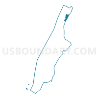
Voting District 7100060, New York County, New York
About
Outline

Summary
| Unique Area Identifier | 631603 |
| Name | Voting District 7100060 |
| County | New York County |
| State | New York |
| Area (square miles) | 0.30 |
| Land Area (square miles) | 0.21 |
| Water Area (square miles) | 0.09 |
| % of Land Area | 70.80 |
| % of Water Area | 29.20 |
| Latitude of the Internal Point | 40.85482730 |
| Longtitude of the Internal Point | -73.92560840 |
Maps

Graphs
Select a template below for downloading or customizing gragh for Voting District 7100060, New York County, New York


Neighbors
Neighoring Voting District (by Name) Neighboring Voting District on the Map
- Voting District 7100058, New York County, NY
- Voting District 7100059, New York County, NY
- Voting District 7100092, New York County, NY
- Voting District 7100100, New York County, NY
- Voting District 7200026, New York County, NY
- Voting District 7200027 7200036-7200038, New York County, NY
- Voting District 7200029, New York County, NY
- Voting District 7200030, New York County, NY
- Voting District 7200033, New York County, NY
- Voting District 7200034, New York County, NY
- Voting District 7200035, New York County, NY
- Voting District 7200039, New York County, NY
- Voting District 7200045, New York County, NY
- Voting District 7200047, New York County, NY
- Voting District 7200048 7200049, New York County, NY
- Voting District 7200050, New York County, NY
- Voting District 7200067, New York County, NY
- Voting District 7700013, Bronx County, NY
- Voting District 7700014 7700015 7700018-7700020 7700081, Bronx County, NY
- Voting District 7700016 7700017, Bronx County, NY
- Voting District 7800051, Bronx County, NY
- Voting District 7800073, Bronx County, NY
Top 10 Neighboring County Subdivision (by Population) Neighboring County Subdivision on the Map
Top 10 Neighboring Place (by Population) Neighboring Place on the Map
Top 10 Neighboring Unified School District (by Population) Neighboring Unified School District on the Map
Top 10 Neighboring State Legislative District Lower Chamber (by Population) Neighboring State Legislative District Lower Chamber on the Map
- Assembly District 77, NY (126,463)
- Assembly District 71, NY (122,886)
- Assembly District 78, NY (121,803)
- Assembly District 72, NY (117,394)
Top 10 Neighboring State Legislative District Upper Chamber (by Population) Neighboring State Legislative District Upper Chamber on the Map
- State Senate District 28, NY (321,361)
- State Senate District 30, NY (318,569)
- State Senate District 33, NY (314,246)
- State Senate District 31, NY (292,157)
Top 10 Neighboring 111th Congressional District (by Population) Neighboring 111th Congressional District on the Map
Top 10 Neighboring Census Tract (by Population) Neighboring Census Tract on the Map
- Census Tract 261, New York County, NY (12,087)
- Census Tract 291, New York County, NY (11,288)
- Census Tract 269, New York County, NY (8,428)
- Census Tract 283, New York County, NY (7,627)
- Census Tract 285, New York County, NY (7,216)
- Census Tract 277, New York County, NY (7,086)
- Census Tract 205.01, Bronx County, NY (6,996)
- Census Tract 53, Bronx County, NY (4,669)
- Census Tract 201, Bronx County, NY (4,013)
- Census Tract 299, New York County, NY (3,834)
Top 10 Neighboring 5-Digit ZIP Code Tabulation Area (by Population) Neighboring 5-Digit ZIP Code Tabulation Area on the Map
- 10453, NY (78,309)
- 10468, NY (76,103)
- 10452, NY (75,371)
- 10033, NY (53,926)
- 10040, NY (41,905)
- 10034, NY (38,908)
- 10039, NY (24,527)